Check out our latest products
A new approach uses sensors, AI, and ecological modelling to reduce animal-vehicle collisions, improving safety and reducing costs for wildlife and transportation systems.
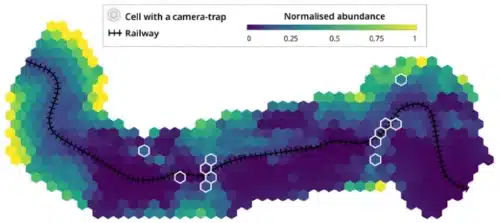
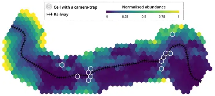
A research team from OïkoLab and TerrOïko, France, has developed a method to reduce collisions between animals and vehicles. This method leverages the increasing number of sensors in transportation systems and their digital twins. Using a network of camera traps, the team aims to map the collision risks between trains and wild animals like wild boar and roe deer.
Animal vehicle collisions threaten human safety, conservation efforts, and transportation infrastructure, leading to significant costs for users and managers. The researchers have proposed a new approach to address this issue.

The process begins by using ecological modelling software to simulate the most likely animal movements within and around an infrastructure, helping to identify potential crossing points.
Once collision hotspots are identified, ecological modelling is used again to guide the placement of photosensors in the field. Various deployment scenarios are modelled to find the best match for the initial simulation’s expected outcomes.
After deploying the sensors, artificial intelligence (deep learning) is used to analyze the data (in this case, images) to identify and track animal species in the area around the infrastructure.
The data is then fed into an abundance model, another ecological tool that estimates the density of animals in different areas based on data from a few key points. The result is a map showing species abundance, which helps evaluate the collision risk along the infrastructure.
While this approach was tested on a railway segment in southwest France, it can be applied to any transportation system, both new and existing, as part of environmental impact assessments.
This method also paves the way for incorporating biodiversity-focused monitoring systems into transportation infrastructure and their digital twins. In the future, sensors that continuously collect data could help create dynamic, adaptive maps and provide real-time information to drivers, reaching autonomous vehicles.
Reference: Sylvain Moulherat et al, Biodiversity monitoring with intelligent sensors: An integrated pipeline for mitigating animal-vehicle collisions, Nature Conservation (2024). DOI: 10.3897/natureconservation.57.108950


![[5G & 2.4G] Indoor/Outdoor Security Camera for Home, Baby/Elder/Dog/Pet Camera with Phone App, Wi-Fi Camera w/Spotlight, Color Night Vision, 2-Way Audio, 24/7, SD/Cloud Storage, Work w/Alexa, 2Pack](https://m.media-amazon.com/images/I/71gzKbvCrrL._AC_SL1500_.jpg)


![[3 Pack] Sport Bands Compatible with Fitbit Charge 5 Bands Women Men, Adjustable Soft Silicone Charge 5 Wristband Strap for Fitbit Charge 5, Large](https://m.media-amazon.com/images/I/61Tqj4Sz2rL._AC_SL1500_.jpg)


